The geology of Havering village consists of deposits of clays, gravels and sands variously classed as ‘bedrock’ and ‘superficial’ deposits. Clays and sands record two periods of very different extreme climate. The youngest, surficial deposits are associated with an ice age when most of Britain was covered by thick ice. The older sedimentary rocks were deposited during a period when Havering was under warm tropical seas.
1. Superficial deposits
Most of the superficial deposits are related to the Anglian glaciation that took place about 450,000 years ago during the Quaternary period. At this time most of Britain was covered by thick sheets of ice rather like Greenland today. Havering would have been at the southern limits of the ice sheet and so was it was unlikely to have been covered by thick or long-lived ice.
Sediments deposited in a glacial–ice sheet environment is classified as either direct glacial products (tills) or indirect (fluvioglacial, or glaciomarine). The geology of Havering contains examples of both types of deposit.
The British Geological Survey (BGS) identify five types of superficial deposit in the Havering area, shown on the map below:
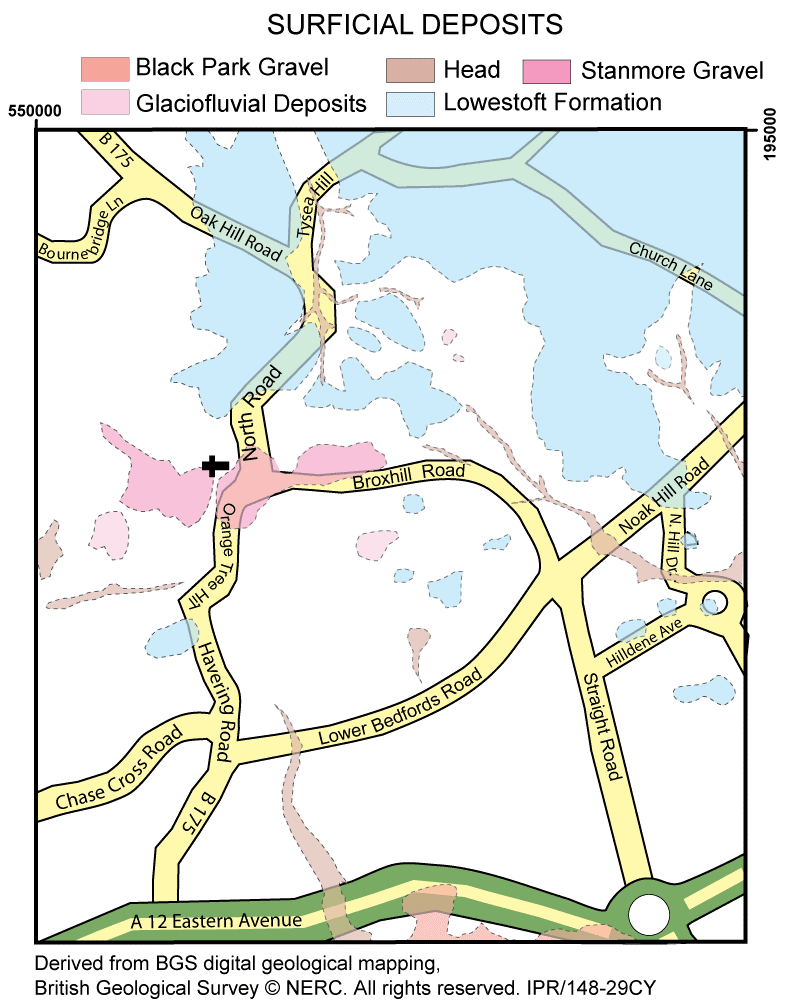
Descriptions of mapped superficial units
Head: A term used to describe a poorly sorted mix of gravels, sands and clays that accumulated by solifluction and soil creep. These are gravity-driven processes that cause the slow movement of waterlogged sediment down hillslopes. Normally associated with areas bordering glaciers or ice sheets.
Glaciofluvial Deposits: A bucket term to describe sands and gravels with lenses of silt, clay or organic material deposited by rivers supplied by glacial meltwaters.
Black Park Gravel: Is a name given to 1-6m thick layers ofsands and gravels with lenses of silt, clay or peat in the Thames valley region that were deposited by rivers that flowed 450,000 years ago during what is known as the Anglian stage.
The Lowestoft Formation: This is a chalky till (chaotic mix of fine material with large clasts of chalk and flint), together with outwash sands and gravels, silts and clays. The till is characterised by its chalk and flint content. The tills across Havering are thought to represent the southern limit of the Anglian Ice sheet.
Stanmore Gravel: Flint rich gravels and sands supported by an orange, brown to pale grey silty clay matrix. These deposits date to the Middle Pleistocene (130,000 to 780,000 years ago). Their origin is debated. Some argue for deposition within an offshore or beach environment others interpret them as river deposits possibly related to the forerunner of the River Thames drainage system that 600,000 years ago flowed much further to the northeast.
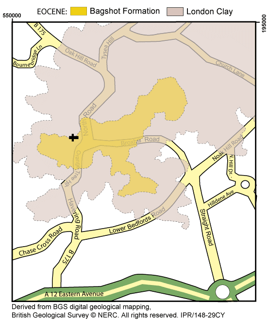
2. Bedrock Geology Below the glacial tills and river deposits are much older deposits classed as bedrock. In the Havering area the British Geological Survey map two sedimentary bedrock units deposited in the Eocene Period, which lasted between 34 and 56 million years ago.
During the early part of the Eocene, between 56 and 48 million years ago, most of Essex and London was covered by sea. The main land area was in the present-day Midlands, from which rivers flowed southeast. The Earth’s atmosphere at that time contained three times more CO2 than today and therefore the climate and vegetation was tropical to sub-tropical, similar in many respects to the present-day Malay Peninsula. Hard to believe, but yes Havering once had a tropical climate!
The start of the Eocene was marked by a rise in sea levels and retreat of coastlines inland. This marine transgression led to the deposition of the London Clay, which is the most extensive rock unit under Havering. The clay has a bluish grey colour and includes silty and sandy clay intervals. Fossils diagnostic of a marine environment (shark teeth, starfish, crabs, lobsters, fish, turtles, bivalves and gastropods) and are often found in concretions and hard layers (known as cement stones) within the clay.
Later, a combination of a drop in sea level and uplift of the land surface led to the formation of large river deltas that expanded eastwards leading to shallow marine conditions in a near coastal setting recorded by sands and gravels of the Bagshot Formation. This unit is found below the village green, St Francis Hospice and large parts of Bedford’s Park, and were deposited on top of the London Clay. The sands are white to buff or crimson in colour and include thin layers of pale clay and localised beds of pebble gravels rich in flint. Fossils are rare but occasionally marine molluscs can be found.
Economic Geology (historical)
Kilns: The thick clays in Havering have long been used for tile and brickmaking. Documents of medieval Assizes held in the Essex records office mention tile making in Havering in the 15th century. Brickells’ (derived from Brick fields) on the south side of Havering Park may have been the site of a brick kiln in Tudor times or earlier. The bend in Orange Tree Road was once known as brick kiln corner, the actual kilns would have been sited to the west of Elmer Avenue. The1777 Chapman and Andre map of Essex shows kilns on Orange Tree Hill and at the junction between what is now the Straight Road and Lower Bedford’s Road. These kilns are also shown on an 1805 map. A new brick kiln location appears on the 1881 OS map in Broxhill Road, downhill of the South Lodge. Another kiln is placed behind Fernside. By 1921 maps refer to these two sites as the Brickfields and Brick Yard respectively suggesting that by this time the kilns were no longer in use. An old resident with long family roots in the village believed that that the yellow bricks used to build the houses on the green next to the church hall came from a local brick kiln.
Water supply: Before a piped water supply reached the village all water came from local wells. A village pump was located on the wall next to the Blacksmiths and Knightsbridge butchers, next door, also had their own pump. Other properties around the village have reported finding disused wells. In most cases the water would have come from shallow aquifers, most likely from within the Stanmore Gravels. The much deeper chalk aquifer would have been very expensive to access and only the large farms and grand houses in the area could have drawn water from the chalk.
The chalk is classified by the Environment Agency as a ‘Major Aquifer’ (layer of water-bearing permeable rock, gravel, sand, or silt from which groundwater can be extracted). It provides clean water because it is normally protected from pollution by the sealing layer of London Clay that lies above it. In the Havering area the chalk is found at great depth, between 150 and 250m below the surface. Pyrgo Park Farm has a functioning well constructed in 1887 that continues to deliver high purity water. The water comes from the Upper Chalk breached at a depth of 602 feet.
Further Information
A detailed history of the Pleistocene glaciations and impacts of regional river systems can be found at: http://www.qpg.geog.cam.ac.uk/research/projects/nweurorivers/
More on the Eocene paleogeography of southern Britain can be found at;
http://www.qpg.geog.cam.ac.uk/research/projects/tertiaryrivers/
Professor Andrew Carter, Broxhill Road