Following the death of Mrs McIntosh in 1923, the majority of the Havering Park estate was sold in 1924 to Allen Ansell a developer, who for a time lived at Priests in Romford. With this purchase came the manorial rights to the Manor of Havering. Ansell, as he did in Rainham following his purchase of Brights and Parsonage Farm, divided the land to be sold in plots. Ansell, described by a friend as one of the “largest individual dealers in estate properties throughout the country”, was killed in a car accident on 28th July 1933.
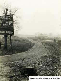
Entrance to Essex Road (later Cedar Road), Havering Park c.1930 the sign erected by Allen Ansell directing those interested in purchasing plots to their sales hut in Clockhouse Lane. Just below the name Allen Ansell is a makeshift sign for Essex Road.
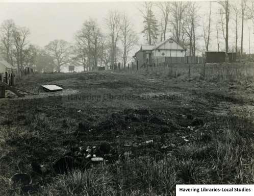
View of Havering Park Estate 1930s, just visible at the top of the hill are “Plotlands” huts
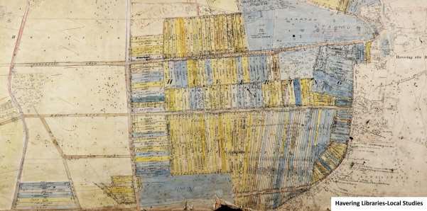
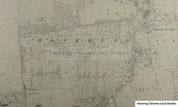
Detailed plotholders plan of Havering Park c. 1929-1935. This annotated plan based on the 1920 Ordnance Survey map illustrates perfectly the measured out plots for sale. The name of each plotholder is written on the plot. Wellingtonia Avenue, Pinewood Road, Essex Road (later St John’s Road) and Clockhouse Lane form the main roads with plots attached. Bridge Road, Elm Road and Foreberry Road are also labelled.
The book “Arcadia For All – the legacy of a makeshift landscape” (1984) by Dennis Hardy & Colin Ward provides a vivid impression of life for the “plotlanders” at Havering Park, but also reflects on how the original idyll was changed by war.
“Though only a stone’s throw from London, a weekend at Havering Park was another world. Mrs. Biggs is one of those who fondly recalls a childhood spent in this way. In 1928 her father, a steel erector by trade, bought and acre and a quarter for £60, repayable in instalments that were taken to an estate agent’s shed on the corner of Clockhouse Lane. First, a single roomed hut was built and then, over a period, it was gradually extended into an attractive three roomed bungalow- mainly of timber, with a corrugated iron roof. Relatives often came down for weekends and holidays, sleeping in a bell tent that was kept for the purpose. Water had to be fetched from a pump in the nearby village of Havering-atte-Bower, until the family installed a water butt with charcoal filter. Flowers, soft fruits and ornamental trees were grown on the spacious plot, and in school Mrs. Biggs was often called upon to stand up and tell her classmates about, ’Nature’.
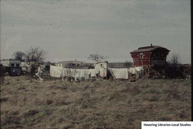
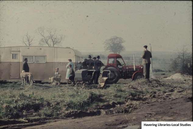
They were, above all, temporary retreats from life in a smoky, urban environment and there is little evidence of permanent occupation in the early years. Prices remained low throughout the 1930s. By the end of the Second World War, though, things were changing. As happened in South Essex, many plotholders had sent their families into the country during the war and some stayed on permanently. And in spite of restrictions on building imposed by the new Green Belt policy, small businesses often managed to gain a foothold. Some claimed existing use rights, while others introduced a further range of urban fringe uses like stables, breeding kennels, scrapyards and storage areas – all of which grew over the years. Meanwhile, new housing development in Collier Row brought the edge of Greater London to the very boundaries of Havering Park.”
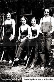
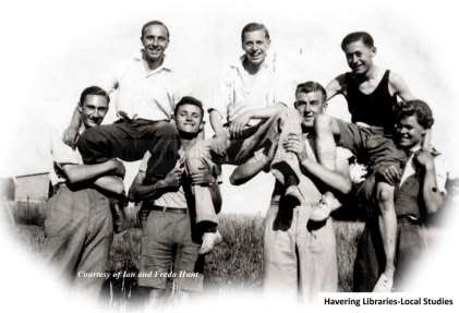
(Left) Circa 1935 The Taylor family recreational plot in Wellingtonia Avenue, Havering – From the left they are Vera Adams, who married Fred Taylor in the latter months of 1939, Violet, Vera’s stepsister, unknown and Doreen Taylor, Fred’s sister. (Right) Fred Taylor and friends at his family’s weekend hut in Wellingtonia Avenue, 1937. Fred was the son of Walter Frederick Taylor, master bootmaker, and Clara Taylor nee Osborne of 94, Mawney Road in Romford. Even living so close, a “weekend hut” on their countryside plot offered a break away from urban living.
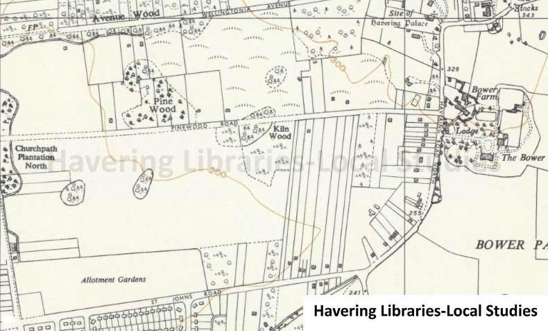
The 1937 Ordnance Survey map shows a less busy plan of the plotlands estate at Havering Park and provides evidence of individuals extending their own land holdings through the purchase of neighbouring plots.
In 1961, Essex County Council took the decision to clear the remaining “plotlanders” and the Greater London Council followed through on this decision when they assumed responsibility in 1965.
This extract from the 1961 Ordnance Survey reveals that fewer plots had survived and much of Havering Park was abandoned to scrubland and semi wilderness with fewer than 30 buildings visible on the map.
Following a survey, compulsory purchase of the site was raised and between September 29th and October 1st 1971 a public inquiry was held in the Town Hall, Romford, which was reported in detail by the “Havering and Romford Express” of 1st and 8th October 1971.
“Pinewood Road residents protested about their land being taken for a Havering regional park at an inquiry at Havering Town Hall on Wednesday (29th September 1971). Appearing for them Mr. Tony Deakin said that at a cost of £200,000 people’s homes, land and businesses would be ‘turned into picnic areas’
Most of them he said had built their own homes and created their own businesses, dealing in livestock, poultry, scrap metal and cars. He read a letter from Mr. J. H. Tinsley as an example. Mr. Tinsley bought his land in 1959. He bought it with a view to his retirement. He has built stables for horses and has three sheds.
Mr. P.R. Claydon of Pinewood Road said that if Bedford’s Park was taken as an example of how much such a park was used, ‘You needn’t bother’. He said he walked through Bedford’s Park every day. Never at any time have I seen enough people in Bedford’s Park to warrant its upkeep’. Mr Claydon said he had a high class greyhound business.
Lord Colville for the Greater London Council said if the compulsory purchase order went through, all the owners would be offered alternative accommodation. The area is bordered by Clockhouse Lane, Orange Tree Hill, Pinewood Road, St. John’s Road and Wellingtonia Avenue.
Earlier Lord Colville said the park would cover 150 acres. Havering village was a conservation area he said, and would be surrounded by parkland. He said there were 150 plots of land and some houses and bungalows in this area. Some of the land was used for agricultural purposes, it was subject to rubbish dumping, car dumping and trouble with gipsies.
Lord Colville continued He said the condition of Wellingtonia Avenue was, ‘pretty rough’. Pinewood Avenue was a ‘real spring breaker’ and St. John’s Road about the same. They were private roads and some houses scattered about the area of which five were good houses and nine less good.
Some of them were of a bungalow type not in good condition. The GLC and Havering Council would compensate owners at the market price plus consideration for disturbance and removal in compulsory purchase he said. Where some of the property was council owned the tenants would be offered alternative accommodation with type, size and rent preferred being considered.
Mr. Bernard Marsden for Mr. Dennis O’Callaghan of Pinewood Road, said he occupied a house and had riding stables. His house had recently been extended after planning permission had been granted on appeal and stables were being built in consequence of a decision made as recently as 1970. Mr. O’Callaghan wished the riding stables to continue within the park and to live at Pinewood Avenue. Mr. Marsden said this would be convenient to everybody”.
“Mrs. Joyce Bellamy, Planning Officer for the GLC, said that the park was planned as a barrier against continued urban spread. She said Hainault Forest had about 10,000 visitors a day during peak periods and the new park was intended to reduce pressure on the forest with its additional space.
Conservation Society Chairman Mr. Ben Percy-Davis asked for assurance that there would be no development or infilling with houses at Havering Village. GLC Senior Planner Mr. Richard Felton said the only infilling would be in gaps between present houses which did not mean construction of new roads.
At the end of the inquiry Lord Colville said he had Mr Percy-Davis’s permission to sat that conservationists, ‘Warmly support the scheme’ for a park..He then said there were residents in the area who would also like the scheme because they had land they could not develop because it was in the Green Belt. He added this would not be a Victorian style park with formally laid out grounds but natural woodland where people from a large area of London cold go picnicking and engage in other rural pursuits”
The most dramatic deposition to the inquiry, which gave the Havering and Romford Express of 1st October 1971 its front-page headline “Stop Our Trade And My Husband Will Die” was given by Mrs. Lucy Dean of Clockhouse Lane, Collier Row.
The husband of Lucy Dean was former wrestler Alfred “Man Mountain” Dean. Mrs Dean stated that her husband Alfred was, “completely bedridden after an accident in 1960 in which he was completely paralysed’. The couple were married in 1938. Mrs. Dean said they had land at Clockhouse Lane with a bungalow and kennels. She said her husband had a scrap metal business. ‘With my husband’s condition he is likely to be confined to bed for the rest of his life’, she told the inquiry. She added, ‘It is vital that he should be able to control his business from his bedroom’. Mr. Bernard Marden for the Deans said without something to occupy his mind Mr. Dean would ‘vegetate’.
Mr. Dean had been an active man before his injury to his spine. It was important he should continue said his wife, ‘Otherwise he would just give up and died’.
Mr. Michael Tink for Havering Council said this type of business was a ‘bad neighbour’ in the proposed park. Because of the nature of it, it was easy for trespassers to get in and conduct such activities as tyre burning and there had been gipsies in the area he said.”
At the end of the three-day inquiry 14 householders and 27 objectors were left waiting for the Government to decide whether their homes and land would be taken for a Havering Regional Park. Hardy and Ward wrote of the GLC’s case. “Supported by the London Borough of Havering, the Greater London Council painted a picture of squalid conditions, and, significantly, even resorted to the 1875 Public Health Act to legitimize their desire to clear the area. The inquiry as told that most of the site was covered by trees and scrub, with a sporadic pattern of building on the long, narrow plots. Much of the land was disused and owners could not be traced, but some of the plots were in use as smallholdings. Buildings were often of temporary materials and little more than shacks; all lacked main sewerage and most were still lit by oil lamps. In bad weather roads were said to be virtually impassable and a rash of fly tipping, scrapyards and abandoned vehicles added to the shoddy appearance of the area. The local authority argued that permanent improvement would not be permitted because of Green Belt policy, and that the land could be more fully used as public open space rather than for private recreation.”
The plotholders argued that they had been prevented from making improvements with a history of planning application rejections. The emphasis on the 1875 Public Health Act also raised the question that clearing the ‘plotlands’ was about removing an untidy sight rather than creating a public park. Hardy and Ward also noted the case made by naturalists
“Havering Park in its unkempt state had an attraction for naturalists who feared its ‘special character’ would disappear if its future lay in ‘Pop festivals, Battersea type Fu Fair ski slopes or Windsor-type Safari Park’. Likewise, the Essex Bee Keepers Association (Romford Division) had used a plot for years, and pointed to a scarcity of natural pockets like this so close to London.”
Also at the Inquiry, the possibility of a Roman villa on the site emerged. Ian Robertson, the curator of the Passmore Edwards Museum, gave written evidence reported by the Romford Recorder of 8th October 1971, “early investigations showed at least one building. A Roman tile, believed to have come from a heating system, has already been found”.
Excavations by West Essex Archaeology Group in 1971 and 1972 “revealed evidence of Roman occupation in the form of a cobbled surface…”. They returned in 1975, supported by the Passmore Edwards Museum. “Investigations revealed an industrial and agricultural complex dating from the 1st to 5th Centuries AD, comprising a cobbled yard surrounded by gullies and drainage ditches containing in situ evidence of metalworking. Nearby, evidence was found of a cremation cemetery and a large dump of Roman building material, suggesting the presence of substantial Roman farmstead settlement.
Furthermore, sections of a possible penannular ring ditch were excavated, with fragments of a second ring ditch immediately to the west, implying the continuous occupation of the site from the Iron Age (there was disagreement about the interpretation of the Iron Age evidence) …”
The Compulsory Purchase Order went ahead, though it took three years before work could start on clearing the park and 8 years before Havering Country Park was formally opened, reported by Linda Chamberlain in the Romford Recorder of 5th October 1979
“The ambitious conversion of a ‘shanty town’ into a magnificent country park was celebrated with an official opening ceremony on Monday. (1st October 1979). The gates of Havering Country Park were formally opened by Mr. Robert Vigars, Chairman of the Greater London Council. He declared, ‘We’ve come from shanty town to Havering Country Park. It’s a proud day’.
The occasion marked a long struggle by the GLC to buy the 165 acres between Collier Row and Havering-atte-Bower. It took three years of wrangling and a public inquiry before the council could buy the numerous plots of land. Cars and debris littering the area had to be cleared, diseased trees were removed and new ones planted. The total cost of land and development was about £500,000. But, Mr. Dick Kirk, the council’s parks planning officer said it was a small sum and a worthwhile investment.
In Mr. Vigars’ opening speech, he said the land had been chosen because of its special character. It will form part of a chain of hilltop parks, which it is hoped, will one day be connected. Although it is very small in size it is important as the gateway to the Havering region. As time goes on it will be looked up from one area to another’, said Mr. Vigars. The park offers a network of paths for walking and horse riding. It has a car park and has already been well used by local people.”
Concessions were made. Mr. and Mrs. Dean were permitted to continue occupation during their lifetime. Their bungalow, “Hillside” in Clockhouse Lane with its associated business still remains. An area in the woods was also granted to Romford Branch beekeepers to continue the collection of honey.
Hardy and Ward concluded
…”By the 1970s the innocence of Arcadia had been at least partially replaced in this area by opportunistic traders and others with little apparent sympathy for the original sense of the place. It is probable that at Havering Park the Greater London Council was right to claim that Londoners would benefit more from its planned public ownership than from its previous subdivision into private plots”.
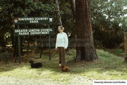
In 1986, following the abolition of the GLC, Havering Country Park was transferred to Havering Council. A guide to the park c.1990 notes that, “One of the bungalows is now the Park Office”.
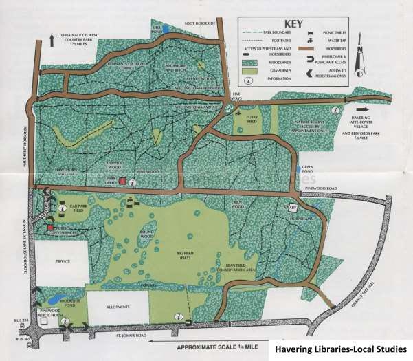
Plan of Havering Country Park included in a 1990s guide. The Park Office, identified on the plan, had been one of the plotland huts. The area marked Private includes the property of Alfred “Man Mountain” Dean and his wife Lucy. Alfred died on 27th August 1992
Simon Donoghue Local History Librarian August 2025
Havering Museum